
Mapa topográfico Zaragoza
Mapa interactivo
Haga clic en el mapa para ver la altitud.
Zaragoza
En la ribera y en el área urbana, el terreno es llano por lo general, sobre todo en la parte norte de la ciudad asentada en la margen derecha de la desembocadura del río Gállego, mientras que la sur tiene una inclinación más pronunciada conforme se aleja del Ebro. La altura del río Ebro a su paso por Zaragoza es de 199 m s. n. m., aunque gran parte de la ciudad está por encima de los 210 m s.n.m. y los barrios del sur como Torrero y La Paz, se encuentran a más de 250 m s.n.m. La ribera está rodeada de escarpes, cornisas o cárcavas dando lugar a relieves abruptos, en ocasiones con fuertes desniveles. En contraste altitudinal respecto al área metropolitana, dentro del municipio, destacan la Plana de Muses, un segmento meridional de los Montes de Castejón a 730 metros de altitud, y las Planas de María por encima de los 600 m s.n.m., resultado de la dureza de sus materiales geológicos a la erosión.
Acerca de este mapa
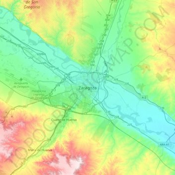
Nombre: Mapa topográfico Zaragoza, altitud, relieve.
Lugar: Zaragoza, Aragón, 50001, España (41.49213 -1.04094 41.81213 -0.72094)
Altitud media: 310 m
Altitud mínima: 169 m
Altitud máxima: 646 m