
Haz una donación
Mapa topográfico Almoster
Haga clic en el mapa para ver la altitud.
Haz una donación
Almoster
Su término está accidentado en el norte por montañas que son un contrafuerte de las montañas de Prades. Todo el término pertenece a la cordillera Prelitoral. El punto más elevado del núcleo urbano es de 320 m de altitud, la iglesia parroquial de San Miguel, se halla a una altitud en la parte más baja del término que és de unos 290 m sobre el nivel del mar, mientras que el punto más elevado del municipio se halla a 700 m de altitud, en la ladera sur del Puig d'en Cama, cerro que domina el paisaje de la zona (más de 100km) y cuyo vértice a 717 m de altitud se encuentra situado en el vecino término municipal de La Selva del Campo.
Haz una donación
Acerca de este mapa
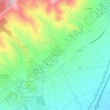
Nombre: Mapa topográfico Almoster, altitud, relieve.
Lugar: Almoster, Bajo Campo, Tarragona, Cataluña, 43393, España (41.17606 1.09114 41.21606 1.13114)
Altitud media: 289 m
Altitud mínima: 139 m
Altitud máxima: 613 m
Haz una donación