
Mapa topográfico Mieres
Mapa interactivo
Haga clic en el mapa para ver la altitud.
Mieres
En invierno Mieres es una ciudad extraordinariamente fría si tenemos en cuenta su latitud, altitud y distancia de la línea de costa. La media anual de días de nieve es insignificante. Esta nieve es permanente en la cumbre de las montañas que rodean Mieres los meses más fríos del año y muy rara vez desciende a la ciudad y la vega del Caudal debido a la poca altitud (poco más de 200 metros). También durante el invierno son frecuentes las heladas y el aguanieve.
Acerca de este mapa
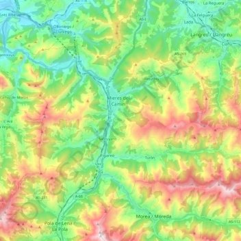
Nombre: Mapa topográfico Mieres, altitud, relieve.
Lugar: Mieres, Asturias, España (43.18111 -5.85553 43.28914 -5.62549)
Altitud media: 497 m
Altitud mínima: 113 m
Altitud máxima: 1.173 m
Otros mapas topográficos
Haga clic en un mapa para ver su topografía, su altitud y su relieve.
Picos de Europa
Las mayores alturas se encuentran en el macizo de los Urrieles, que pasa por ser el más agreste de los tres, pues catorce de sus cimas superan los 2600 m de altitud, con la Torre Cerredo, de 2650 m, como techo de estas montañas y tercer máximo de toda la península ibérica, después de Sierra Nevada y…
Altitud media: 2.290 m
Canle da Central Hidroeléctrica do Louredal
España > Asturias > San Tirso de Abres > Naraído
Altitud media: 167 m
Cordillera Cantábrica
El descenso desde la cordillera al sur (a la meseta) es más gradual, y varios ríos grandes, como el Esla o el Pisuerga, nacen aquí y fluyen hacia el sur o el oeste, formando la cuenca del Duero. La amplitud de la cordillera, con todas sus ramificaciones, aumenta desde aproximadamente 97 km en el este a…
Altitud media: 2.209 m
Torre Cerredo
Torre Cerredo, también nombrada Torrecerredo o Torre de Cerredo (en asturleonés, la Torre Cerréu), con sus 2650 m s. n. m., es la montaña de mayor altitud de Asturias y de Castilla y León, así como de la cordillera Cantábrica.
Altitud media: 2.187 m