
Mapa topográfico Lugo
Mapa interactivo
Haga clic en el mapa para ver la altitud.
Lugo
La topografía de la mayor parte del municipio de Lugo se resuelve en una superficie relativamente llana, entre los 450 y los 600 m, destacando en ella los relieves del suroeste (O Picato, 783 m.) y los del nordeste (Outeiro Maior, 728 m.) con bloques más elevados. La red hidrográfica se encuentra centrada en torno a un gran colector, el río Miño, que inicia su recorrido en la sierra de Meira, trazando en su curso alto un lento recorrido a través de la depresión lucense. A lo largo de su amplio discurrir por el término municipal, recibe por la izquierda las aguas del Fervedoira y del Chamoso, y por la derecha las del Narla y del Mera.
Acerca de este mapa
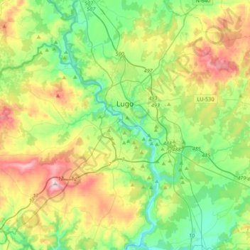
Nombre: Mapa topográfico Lugo, altitud, relieve.
Lugar: Lugo, Galicia, España (42.88330 -7.73527 43.09872 -7.40598)
Altitud media: 489 m
Altitud mínima: 341 m
Altitud máxima: 779 m
Otros mapas topográficos
Haga clic en un mapa para ver su topografía, su altitud y su relieve.
Serra do Careón
España > Galicia > Lugo > Friol
Con una altitud media de 550 metros y máxima de 798 metros, en el monte Careón. Dominan los granitos intrusivos, gneis de "ojo de sapo" y esquistos. En esta sierra nacen el río Narla, afluente del Miño, y el río Pambre, el río Seco y el río Furelos, afluentes los tres del río Ulla.
Altitud media: 730 m