
Gracias por apoyar a este sitio ❤️
Haz una donación
Haz una donación
Mapa topográfico City of Red Deer
Haga clic en el mapa para ver la altitud.
Gracias por apoyar a este sitio ❤️
Haz una donación
Haz una donación
Acerca de este mapa
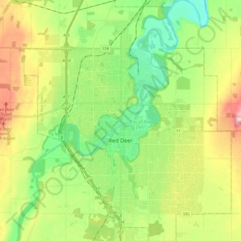
Nombre: Mapa topográfico City of Red Deer, altitud, relieve.
Lugar: City of Red Deer, Alberta, Canadá (52.21574 -113.89773 52.34292 -113.71850)
Altitud media: 890 m
Altitud mínima: 823 m
Altitud máxima: 1.000 m
Gracias por apoyar a este sitio ❤️
Haz una donación
Haz una donación
Otros mapas topográficos
Haga clic en un mapa para ver su topografía, su altitud y su relieve.