Mapa topográfico la Vall de Boí
Mapa interactivo
Haga clic en el mapa para ver la altitud.
Acerca de este mapa
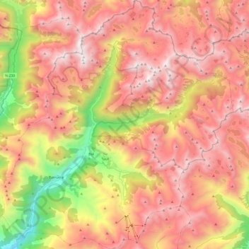
Nombre: Mapa topográfico la Vall de Boí, altitud, relieve.
Lugar: la Vall de Boí, Alta Ribagorça, Lleida, Catalonia, Spain (42.45411 0.73941 42.63191 0.97266)
Altitud media: 2.141 m
Altitud mínima: 936 m
Altitud máxima: 2.989 m
The small town of Durro is situated at an elevation of 1,386 metres, on a south-facing mountainside. The church has a single long and narrow nave with a barrel vault and slate roof. It was built with a single apse, now replaced by a sacristy. Two square chapels have been built into the northern wall, and the bell tower rises from the northeast corner to five storeys. The entrance is cut into the southern wall, to a covered walkway. The building has been renovated and extended many times since it was built in the 12th century and little of its original appearance remains. The interior retains Baroque features from later renovations.
Otros mapas topográficos
Haga clic en un mapa para ver su topografía, su altitud y su relieve.
Vilaller
Spain > Catalonia > Alta Ribagorça
Vilaller, Alta Ribagorça, Lleida, Catalonia, 25552, Spain
Altitud media: 1.845 m