
Mapa topográfico Puyo
Mapa interactivo
Haga clic en el mapa para ver la altitud.
Puyo
Puyo, también conocida como Nuestra Señora del Rosario de Pompeya de Puyo, es una ciudad ecuatoriana; cabecera cantonal del Cantón Pastaza y capital de la Provincia de Pastaza, así como la urbe más grande y poblada de la misma. Se localiza en la orilla izquierda del río Puyo, al centro-occidente de la región amazónica del Ecuador, en los flancos externos de la cordillera oriental de los Andes, a una altitud de 930 m s. n. m. y con un clima lluvioso tropical de 21,1 °C en promedio.
Acerca de este mapa
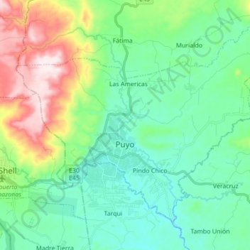
Nombre: Mapa topográfico Puyo, altitud, relieve.
Lugar: Puyo, Pastaza, Ecuador (-1.52890 -78.05687 -1.42083 -77.91932)
Altitud media: 1.022 m
Altitud mínima: 880 m
Altitud máxima: 1.408 m
Otros mapas topográficos
Haga clic en un mapa para ver su topografía, su altitud y su relieve.
Puyo
Ecuador > Pastaza > Pastaza > Puyo
Puyo, también conocida como Nuestra Señora del Rosario de Pompeya de Puyo, es una ciudad ecuatoriana; cabecera cantonal del Cantón Pastaza y capital de la Provincia de Pastaza, así como la urbe más grande y poblada de la misma. Se localiza en la orilla izquierda del río Puyo, al centro-occidente de la…
Altitud media: 970 m