Geolocalizar

Mapa topográfico Hyderabad

Mapa interactivo

Haga clic en el mapa para ver la altitud.

Acerca de este mapa

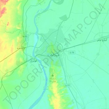
Nombre: Mapa topográfico Hyderabad, altitud, relieve.

Lugar: Hyderabad, , Sindh, 91000, Pakistan (25.22010 68.21504 25.54010 68.53504)

Altitud media: 28 m

Altitud mínima: 8 m

Altitud máxima: 136 m

Located at 25.367 °N latitude and 68.367 °E longitude with an elevation of 13 metres (43 ft), Hyderabad is located on the east bank of the Indus River and is roughly 150 kilometres (93 mi) away from Karachi, the provincial capital. Two of Pakistan's largest highways, the Indus Highway and the National Highway join at Hyderabad. Several towns surrounding the city include Kotri at 6.7 kilometres (4.2 mi), Jamshoro at 8.1 kilometres (5.0 mi), Hattri at 5.0 kilometres (3.1 mi) and Husri at 7.5 kilometres (4.7 mi).