
Gracias por apoyar a este sitio ❤️
Haz una donación
Haz una donación
Mapa topográfico Éibar
Haga clic en el mapa para ver la altitud.
Gracias por apoyar a este sitio ❤️
Haz una donación
Haz una donación
Éibar
La altitud oscila entre los 795 metros (pico Urko), en el límite con la provincia de Vizcaya, y los 90 metros en la desembocadura del río Ego. El casco histórico se alza a 121 metros sobre el nivel del mar.
Gracias por apoyar a este sitio ❤️
Haz una donación
Haz una donación
Acerca de este mapa
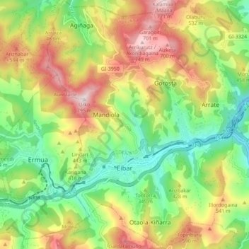
Nombre: Mapa topográfico Éibar, altitud, relieve.
Lugar: Éibar, Bajo Deba, Guipúzcoa, País Vasco, 20600, España (43.16409 -2.49966 43.22589 -2.43239)
Altitud media: 367 m
Altitud mínima: 74 m
Altitud máxima: 768 m
Gracias por apoyar a este sitio ❤️
Haz una donación
Haz una donación