
Mapa topográfico Tre Cime di Lavaredo - Drei Zinnen
Mapa interactivo
Haga clic en el mapa para ver la altitud.
Tre Cime di Lavaredo - Drei Zinnen
El Rifugio Auronzo en las Tres Cimas de Lavaredo ha sido final de etapa del Giro de Italia en siete oportunidades. La subida comienza en Misurina a 1.760 m s. n. m. y en unos 7 kilómetros se llega hasta el refugio a una altitud de 2300. El último tramo tiene un desnivel de 477 metros en menos de 4 km para una pendiente media superior al 12% y picos de hasta el 18%. La primera vez que se ascendió fue en 1967, etapa ganada por Felice Gimondi. Además, ha sido Cima Coppi en cinco de esos siete finales.
Acerca de este mapa
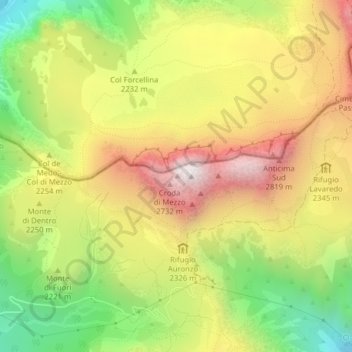
Nombre: Mapa topográfico Tre Cime di Lavaredo - Drei Zinnen, altitud, relieve.
Altitud media: 2.242 m
Altitud mínima: 1.667 m
Altitud máxima: 2.813 m
Otros mapas topográficos
Haga clic en un mapa para ver su topografía, su altitud y su relieve.