
Mapa topográfico Málaga
Mapa interactivo
Haga clic en el mapa para ver la altitud.
Málaga
La ciudad está situada a una altitud de 8 msnm y se abre a una amplia bahía rodeada por las estribaciones meridionales de los Montes de Málaga, que desde el municipio del Rincón de la Victoria, recorren la ciudad paralelas a la costa en dirección este-oeste y que comprenden los montes y cerros de Calderón, San Cristóbal, Victoria, Gibralfaro, Los Ángeles, Coronado, Cabello, La Tortuga y Atalaya, continuando después hacia el interior a lo largo del valle del río Campanillas. Por el lado occidental cierran la bahía las sierras de Cártama y Mijas.
Acerca de este mapa
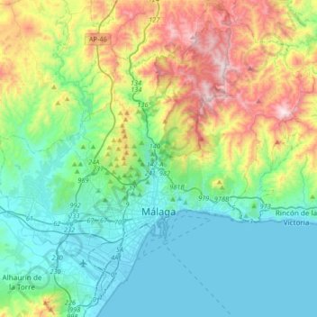
Nombre: Mapa topográfico Málaga, altitud, relieve.
Lugar: Málaga, Málaga-Costa del Sol, Málaga, Andalucía, España (36.63566 -4.58789 36.89404 -4.26049)
Altitud media: 276 m
Altitud mínima: -1 m
Altitud máxima: 1.019 m
Otros mapas topográficos
Haga clic en un mapa para ver su topografía, su altitud y su relieve.
Málaga
España > Andalucía > Málaga-Costa del Sol > Málaga
La ciudad está situada a una altitud de 8 m sobre el nivel del mar y se abre a una amplia bahía rodeada por las estribaciones meridionales de los Montes de Málaga, que desde el municipio del Rincón de la Victoria, recorren la ciudad paralelas a la costa en dirección este-oeste y que comprenden los…
Altitud media: 215 m