
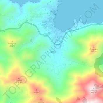
Mapa topográfico Vlichada
Mapa interactivo
Haga clic en el mapa para ver la altitud.
Acerca de este mapa
Nombre: Mapa topográfico Vlichada, altitud, relieve.
Altitud media: 261 m
Altitud mínima: -2 m
Altitud máxima: 872 m
Otros mapas topográficos
Haga clic en un mapa para ver su topografía, su altitud y su relieve.
Alones
Greece > Region of Crete > Rethymno Regional Unit
Alones, Municipality of Rethymnon, Rethymno Regional Unit, Region of Crete, Greece
Altitud media: 691 m
Preveli Palmbeach
Greece > Region of Crete > Rethymno Regional Unit
Preveli Palmbeach, Municipality of Agios Vasileios, Rethymno Regional Unit, Region of Crete, Greece
Altitud media: 86 m
Rethymno
Greece > Region of Crete > Rethymno Regional Unit > Rethymno
Rethymno, Municipality of Rethymnon, Rethymno Regional Unit, Region of Crete, 741 31, Greece
Altitud media: 204 m
Gerani
Greece > Region of Crete > Rethymno Regional Unit > Gerani
Gerani, Municipality of Rethymnon, Rethymno Regional Unit, Region of Crete, Greece
Altitud media: 126 m
Plakias
Greece > Region of Crete > Rethymno Regional Unit
Plakias, Municipality of Agios Vasileios, Rethymno Regional Unit, Region of Crete, 740 60, Greece
Altitud media: 123 m
Agia Galini
Greece > Region of Crete > Rethymno Regional Unit > Agia Galini
Agia Galini, Municipality of Agios Vasileios, Rethymno Regional Unit, Region of Crete, 74056, Greece
Altitud media: 127 m