
Mapa topográfico Lorca
Mapa interactivo
Haga clic en el mapa para ver la altitud.
Acerca de este mapa
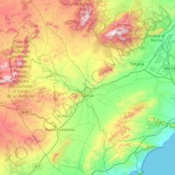
Nombre: Mapa topográfico Lorca, altitud, relieve.
Lugar: Lorca, Alto Guadalentín, Region of Murcia, Spain (37.42102 -2.01265 37.97018 -1.39668)
Altitud media: 537 m
Altitud mínima: -1 m
Altitud máxima: 1.561 m
The town is situated at an elevation of 370 metres (1,200 ft) in eastern Spain between Granada and Murcia. It was part of the hura of Tidmir in the Muslim period when it became well known for its fertile soil and subsoil, and for its strategic location. It is situated on the southern slopes of the Siera del Cano mountains. The Guadalentín River flows through the town.
Otros mapas topográficos
Haga clic en un mapa para ver su topografía, su altitud y su relieve.
Águilas
Spain > Region of Murcia > Alto Guadalentín
Águilas, Alto Guadalentín, Region of Murcia, Spain
Altitud media: 261 m