
Mapa topográfico Traverse City
Mapa interactivo
Haga clic en el mapa para ver la altitud.
Acerca de este mapa
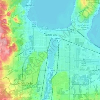
Nombre: Mapa topográfico Traverse City, altitud, relieve.
Altitud media: 204 m
Altitud mínima: 174 m
Altitud máxima: 307 m
The locale and topography is conducive for road bicycling, aided by the TART trail system. A map with routes, different trips, advice and local knowledge is available. Lake Michigan presents a location for sailing, fishing, and kayaking.
Otros mapas topográficos
Haga clic en un mapa para ver su topografía, su altitud y su relieve.
Grand Traverse Bay
United States > Michigan > Grand Traverse County
Grand Traverse Bay, Grand Traverse County, Michigan, 49682, United States
Altitud media: 201 m
Interlochen
United States > Michigan > Grand Traverse County
Interlochen, Green Lake Township, Grand Traverse County, Michigan, 49643, United States
Altitud media: 257 m
Williamsburg
United States > Michigan > Grand Traverse County
Williamsburg, Whitewater Township, Grand Traverse County, Michigan, 49690, United States
Altitud media: 228 m
East Bay Township
United States > Michigan > Grand Traverse County
East Bay Township, Grand Traverse County, Michigan, United States
Altitud media: 252 m