
Mapa topográfico Payson
Mapa interactivo
Haga clic en el mapa para ver la altitud.
Acerca de este mapa
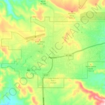
Nombre: Mapa topográfico Payson, altitud, relieve.
Lugar: Payson, Gila County, Arizona, 85072, United States (34.21706 -111.37054 34.27176 -111.27319)
Altitud media: 1.522 m
Altitud mínima: 1.379 m
Altitud máxima: 1.725 m
Located in northern Gila County at an elevation of 5,000 feet (1,500 m), the town has a total area of 19.5 square miles (51 km2). The Mogollon Rim, the southern boundary of the Colorado Plateau, lies to the north of Payson, with elevations exceeding 7,500 feet (2,300 m); there are many cold water lakes on top of the rim. They are stocked with fish by the Arizona Game and Fish Department.
Otros mapas topográficos
Haga clic en un mapa para ver su topografía, su altitud y su relieve.
White Tank
United States > Arizona > Gila County
White Tank, Gila County, Arizona, United States
Altitud media: 1.298 m
White Mountain
United States > Arizona > Gila County
White Mountain, Gila County, Arizona, United States
Altitud media: 1.363 m
Pine
United States > Arizona > Gila County
Pine, Gila County, Arizona, 85544, United States
Altitud media: 1.794 m
Miami
United States > Arizona > Gila County
Miami, Gila County, Arizona, 85539, United States
Altitud media: 1.121 m
Globe
United States > Arizona > Gila County
Globe, Gila County, Arizona, 85532, United States
Altitud media: 1.173 m
Cypress Hill
United States > Arizona > Gila County > Star Valley
Cypress Hill, Star Valley, Gila County, Arizona, United States
Altitud media: 1.440 m
Cedar Mesa
United States > Arizona > Gila County
Cedar Mesa, Gila County, Arizona, United States
Altitud media: 1.638 m
Star Valley
United States > Arizona > Gila County > Star Valley
Star Valley, Gila County, Arizona, United States
Altitud media: 1.521 m