
Mapa topográfico Village of Fort Edward
Mapa interactivo
Haga clic en el mapa para ver la altitud.
Acerca de este mapa
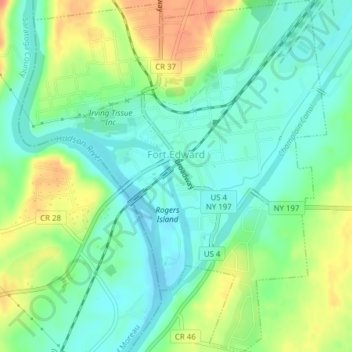
Nombre: Mapa topográfico Village of Fort Edward, altitud, relieve.
Altitud media: 52 m
Altitud mínima: 34 m
Altitud máxima: 83 m
Otros mapas topográficos
Haga clic en un mapa para ver su topografía, su altitud y su relieve.
Bald Mountain
United States > New York > Washington County
Bald Mountain, Washington County, New York, United States
Altitud media: 261 m
Village of Cambridge
United States > New York > Washington County
Village of Cambridge, Town of White Creek, Washington County, New York, United States
Altitud media: 165 m
Town of Dresden
United States > New York > Washington County
Town of Dresden, Washington County, New York, United States
Altitud media: 249 m
Black Mountain
United States > New York > Washington County
Black Mountain, Town of Dresden, Washington County, New York, 12841, United States
Altitud media: 487 m
West Hebron
United States > New York > Washington County > West Hebron
West Hebron, Town of Hebron, Washington County, New York, 12865, United States
Altitud media: 209 m
Putnam Station
United States > New York > Washington County > Putnam Station
Putnam Station, Town of Putnam, Washington County, New York, United States
Altitud media: 83 m
West Cambridge
United States > New York > Washington County > Town of Cambridge
West Cambridge, Town of Cambridge, Washington County, New York, United States
Altitud media: 199 m