
Mapa topográfico Ko Pha Ngan
Mapa interactivo
Haga clic en el mapa para ver la altitud.
Ko Pha Ngan
Due to its topography, the population hugs the coastline. The mountainous interior is generally inaccessible. More than half the island designated as national park and Ko Pha-ngan has more than 80 km2 (31 sq mi) of relatively unspoiled rain forest with diverse flora and fauna. It is also considered a spiritual place, with numerous Buddhist temples around the island and a thriving spa, retreat, and meditation industry.
Acerca de este mapa
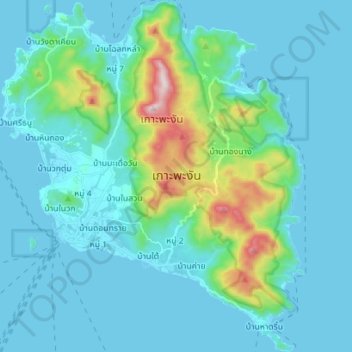
Nombre: Mapa topográfico Ko Pha Ngan, altitud, relieve.
Lugar: Ko Pha Ngan, Ko Pha-Ngan, Surat Thani Province, Thailand (9.66567 99.96074 9.80402 100.08177)
Altitud media: 84 m
Altitud mínima: 0 m
Altitud máxima: 602 m
Otros mapas topográficos
Haga clic en un mapa para ver su topografía, su altitud y su relieve.