
Mapa topográfico Appalachian Mountains
Mapa interactivo
Haga clic en el mapa para ver la altitud.
Acerca de este mapa
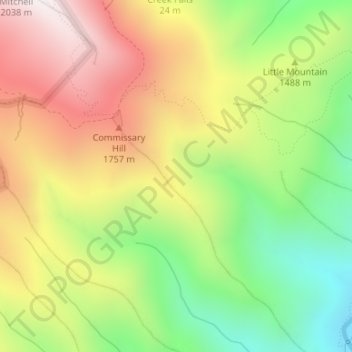
Nombre: Mapa topográfico Appalachian Mountains, altitud, relieve.
Altitud media: 1.463 m
Altitud mínima: 962 m
Altitud máxima: 2.002 m
The Appalachian Mountains (French: Appalaches), often called the Appalachians, are a system of mountains in eastern to northeastern North America. The Appalachians first formed roughly 480 million years ago during the Ordovician Period. They once reached elevations similar to those of the Alps and the Rocky Mountains before experiencing natural erosion. The Appalachian chain is a barrier to east–west travel, as it forms a series of alternating ridgelines and valleys oriented in opposition to most highways and railroads running east–west.
Otros mapas topográficos
Haga clic en un mapa para ver su topografía, su altitud y su relieve.
Burnsville
United States > North Carolina > Yancey County
Burnsville, Yancey County, North Carolina, United States
Altitud media: 882 m
Mount Mitchell
United States > North Carolina > Yancey County
Mount Mitchell, Yancey County, North Carolina, United States
Altitud media: 1.743 m
Mitchell Ridge
United States > North Carolina > Yancey County
Mitchell Ridge, Yancey County, North Carolina, United States
Altitud media: 1.517 m
Cane River
United States > North Carolina > Yancey County > Low Gap
Cane River, Low Gap, Yancey County, North Carolina, 28714, United States
Altitud media: 944 m
Cane River
United States > North Carolina > Yancey County > Eskota
Cane River, Eskota, Yancey County, North Carolina, United States
Altitud media: 1.154 m
Lost Cove
United States > North Carolina > Yancey County > Lost Cove
Lost Cove, Yancey County, North Carolina, United States
Altitud media: 852 m