
Mapa topográfico Dolores County
Mapa interactivo
Haga clic en el mapa para ver la altitud.
Acerca de este mapa
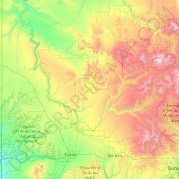
Nombre: Mapa topográfico Dolores County, altitud, relieve.
Lugar: Dolores County, Colorado, United States (37.48072 -109.04348 37.89640 -107.86155)
Altitud media: 2.385 m
Altitud mínima: 1.473 m
Altitud máxima: 4.265 m
Dolores County, like other counties in Colorado along its border with Utah, is split into two geographically distinct regions, and in fact, under normal travel conditions, it is necessary to leave the county to travel between the two regions. The western portion of the county (east of the Dolores River Canyon and along the Utah border) is the northern portion of the Great Sage Plain, relatively low (6500–7500 feet in elevation) and flat (but cut by large canyons, including that of the Dolores River itself), and consists of irrigated and dryland farming areas; it is especially well known for the cultivation of various varieties of beans, including pinto beans and many variety of old Anasazi beans. The central portion of the county has higher open grasslands with forested hills, ravines, and canyons, used for livestock raising. The eastern portion of the county is located in the highest peaks of the San Juan Mountains, around the old mining and modern tourist town of Rico, and except for cattle grazing in the San Juan National Forest, has virtually no agriculture, in part because its elevations range from 9,000 to 14,000+. Rico is developing in many ways as a bedroom community for the much wealthier town of Telluride in San Miguel County to the north.
Otros mapas topográficos
Haga clic en un mapa para ver su topografía, su altitud y su relieve.
Vail
United States > Colorado > Eagle County
Vail, Eagle County, Colorado, 81657, United States
Altitud media: 2.953 m
Mount Jackson
United States > Colorado > Eagle County
Mount Jackson, Eagle County, Colorado, United States
Altitud media: 3.724 m
Archuleta County
Archuleta County, Colorado, United States
Altitud media: 2.599 m
The Sandbox
United States > Colorado > Boulder
The Sandbox, Boulder, Boulder County, Colorado, United States
Altitud media: 1.599 m
Grand Junction
United States > Colorado > Mesa County
Grand Junction, Mesa County, Colorado, United States
Altitud media: 1.470 m
Bayfield
United States > Colorado > Bayfield
Bayfield, La Plata County, Colorado, United States
Altitud media: 2.130 m
Granite
United States > Colorado > Granite
Granite, Chaffee County, Colorado, 81228, United States
Altitud media: 2.841 m
Aspen
United States > Colorado > Pitkin County
Aspen, Pitkin County, Colorado, United States
Altitud media: 2.568 m
San Juan County
San Juan County, Colorado, 81433, United States
Altitud media: 3.478 m
Clear Creek County
Clear Creek County, Colorado, United States
Altitud media: 3.145 m
The Flat Tops
The Flat Tops, Mesa County, Colorado, United States
Altitud media: 3.207 m
Las Animas County
Las Animas County, Colorado, United States
Altitud media: 1.771 m
Trinidad
United States > Colorado > Las Animas County > Trinidad
Trinidad, Las Animas County, Colorado, 81082, United States
Altitud media: 1.907 m
Costilla County
Costilla County, Colorado, United States
Altitud media: 2.655 m