
Mapa topográfico Presidio County
Mapa interactivo
Haga clic en el mapa para ver la altitud.
Acerca de este mapa
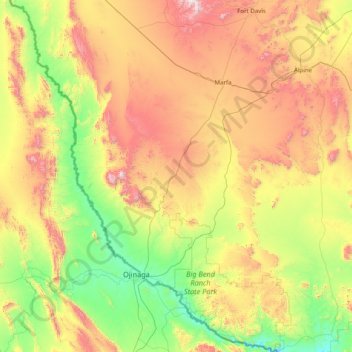
Nombre: Mapa topográfico Presidio County, altitud, relieve.
Lugar: Presidio County, Texas, United States (29.25837 -104.98075 30.62940 -103.79246)
Altitud media: 1.255 m
Altitud mínima: 716 m
Altitud máxima: 2.348 m
Geographically, Presidio County comprises 3,857 square miles (9,990 km2) of contrasting topography, geology, and vegetation. In the north and west, clay and sandy loam cover the rolling plains known as the Marfa Plateau and the Highland Country, providing good ranges of grama grasses for the widely acclaimed Highland Herefords. In the central, far western, and southeastern areas of the county, some of the highest mountain ranges in Texas are found. These peaks are formed of volcanic rock and covered with loose surface rubble. They support desert shrubs and cacti and dominate a landscape of rugged canyons and numerous springs. The spring-fed Capote Falls, with a drop of 175 feet (53 m), the highest in Texas, is located in western Presidio County. In the southern and western parts of the county, the volcanic cliffs of the Candelaria Rimrock (also called the Sierra Vieja) rise perpendicular and run parallel to the river, separating the highland prairies from the desert floor hundreds of feet below them. The gravel pediment, which allows only the growth of desert shrubs and cacti, extends from the Rimrock to the flood plain of the river. Along the river, irrigation allows the farming of vegetables, grains, and cotton. No permanent streams exist in the county, although many arroyos become raging torrents during heavy rainfalls. Major ones are Alamito Creek, Cibolo Creek, Capote Creek, and Pinto Canyon. San Esteban Dam was built across Alamito Creek and on the site of a historic spring-fed tinaja in 1911 as an irrigation and land-promotion project. Altitudes in the county vary from 2,518 to 7,728 feet (767 to 2,355 m) above sea level. Temperatures, moderated by the mountains, vary from 33 °F (1 °C) in January to 100 °F (38 °C) in July. Average rainfall is 12 inches (300 mm) per year, mainly in June, July, and August. The growing season extends for 238 days. Natural resources under production in 1982 were perlite, crushed rhyolite, sand, and gravel. Silver mining contributed greatly to the economy of the county from the 1880s to the 1940s. Presidio County has no oil or gas production.
Otros mapas topográficos
Haga clic en un mapa para ver su topografía, su altitud y su relieve.
Mathew Lake Dam
United States > Texas > Dallas County > Sunnyvale
Mathew Lake Dam, Sunnyvale, Dallas County, Texas, 75182, United States
Altitud media: 137 m
San Antonio
United States > Texas > Bexar County
San Antonio, Bexar County, Texas, United States
Altitud media: 247 m
Houston
United States > Texas > Harris County
Houston, Harris County, Texas, United States
Altitud media: 25 m
Socorro
United States > Texas > El Paso County
Socorro, El Paso County, Texas, 79927, United States
Altitud media: 1.127 m
Round Rock
United States > Texas > Williamson County
Round Rock, Williamson County, Texas, United States
Altitud media: 242 m
Junction
United States > Texas > Kimble County
Junction, Kimble County, Texas, 76849, United States
Altitud media: 532 m
Cypress
United States > Texas > Harris County
Cypress, Harris County, Texas, 77433, United States
Altitud media: 46 m
Lamesa
United States > Texas > Dawson County
Lamesa, Dawson County, Texas, 79331, United States
Altitud media: 907 m
Dish
United States > Texas > Denton County
Dish, Denton County, Texas, United States
Altitud media: 201 m
Murphy
United States > Texas > Collin County
Murphy, Collin County, Texas, 75094, United States
Altitud media: 169 m
Plains
United States > Texas > Yoakum County
Plains, Yoakum County, Texas, United States
Altitud media: 1.113 m
The Woodlands
United States > Texas > Montgomery County
The Woodlands, Montgomery County, Texas, United States
Altitud media: 47 m
Emory
United States > Texas > Rains County
Emory, Rains County, Texas, United States
Altitud media: 149 m
Lago Vista
United States > Texas > Travis County
Lago Vista, Travis County, Texas, United States
Altitud media: 251 m
Park Place
United States > Texas > Harris County > Houston
Park Place, Houston, Harris County, Texas, 77017, United States
Altitud media: 11 m
Earth
United States > Texas > Lamb County > Earth > Earth
Earth, Lamb County, Texas, 79301, United States
Altitud media: 1.129 m
San Antonio
United States > Texas > Bexar County > San Antonio
San Antonio, Bexar County, Texas, 78205, United States
Altitud media: 218 m
Elevation
United States > Texas > Milam County
Elevation, Milam County, Texas, United States
Altitud media: 150 m
Brazoria County
United States > Texas > Brazoria County
Brazoria County, Texas, United States
Altitud media: 10 m
Nueces County
United States > Texas > Nueces County
Nueces County, Texas, United States
Altitud media: 23 m
Gonzales County
United States > Texas > Gonzales County
Gonzales County, Texas, United States
Altitud media: 114 m
Sun Valley
United States > Texas > Lamar County
Sun Valley, Lamar County, Texas, United States
Altitud media: 166 m
Beaumont
United States > Texas > Beaumont
Beaumont, Jefferson County, Texas, United States
Altitud media: 6 m
Rotan
United States > Texas > Fisher County
Rotan, Fisher County, Texas, 79546, United States
Altitud media: 598 m
Lockhart
United States > Texas > Lockhart
Lockhart, Caldwell County, Texas, 78644, United States
Altitud media: 156 m
Hardeman County
Hardeman County, Texas, 79252, United States
Altitud media: 459 m
Medio Island
United States > Texas > Cameron County
Medio Island, Cameron County, Texas, United States
Altitud media: 3 m