
Mapa topográfico Charleroi
Mapa interactivo
Haga clic en el mapa para ver la altitud.
Acerca de este mapa
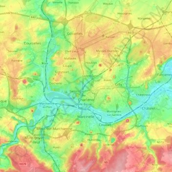
Nombre: Mapa topográfico Charleroi, altitud, relieve.
Lugar: Charleroi, Hainaut, Wallonia, Belgium (50.35284 4.34811 50.49243 4.50755)
Altitud media: 152 m
Altitud mínima: 92 m
Altitud máxima: 233 m
The topography of Charleroi is influenced by the valley of the river Sambre, which flows from west to east before joining the Meuse at Namur. The Piéton river flows from north to south to join the Sambre at Dampremy. The Charleroi-Brussels canal is dug in the valley of this stream. The Eau d'Heure river comes from the south and also flows into the Sambre at Marchienne-au-Pont. About twenty streams run through the territory of the municipality.
Otros mapas topográficos
Haga clic en un mapa para ver su topografía, su altitud y su relieve.
Forchies-la-Marche
Belgium > Hainaut > Charleroi > Fontaine-l'Évêque
Forchies-la-Marche, Fontaine-l'Évêque, Charleroi, Hainaut, Wallonia, 6141, Belgium
Altitud media: 171 m
Pont-à-Celles
Pont-à-Celles, Charleroi, Hainaut, Wallonia, Belgium
Altitud media: 147 m