
Mapa topográfico Bhuj
Mapa interactivo
Haga clic en el mapa para ver la altitud.
Bhuj
Bhuj has an average elevation of 110 metres (360 feet). On the eastern side of the city is a hill known as Bhujia Hill, on which there is a Bhujia Fort, that separates Bhuj city and Madhapar town ( considered one of the richest villages in Asia ). It has two lakes namely Hamirsar and Deshadsar (દેેેશળસર).
Acerca de este mapa
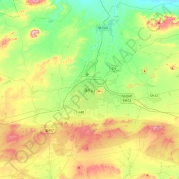
Nombre: Mapa topográfico Bhuj, altitud, relieve.
Lugar: Bhuj, Bhuj Taluka, Kachchh, Gujarat, 370001, India (23.08724 69.50834 23.40724 69.82834)
Altitud media: 130 m
Altitud mínima: 10 m
Altitud máxima: 336 m
Otros mapas topográficos
Haga clic en un mapa para ver su topografía, su altitud y su relieve.