
Mapa topográfico Chalkida
Mapa interactivo
Haga clic en el mapa para ver la altitud.
Acerca de este mapa
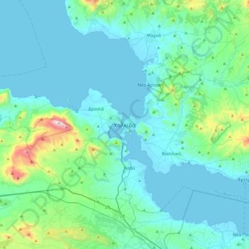
Nombre: Mapa topográfico Chalkida, altitud, relieve.
Altitud media: 129 m
Altitud mínima: -1 m
Altitud máxima: 1.006 m
Otros mapas topográficos
Haga clic en un mapa para ver su topografía, su altitud y su relieve.
Marmari
Greece > Thessaly and Central Greece > Euboea Regional Unit
Marmari, Karystos Municipality, Euboea Regional Unit, Central Greece, Thessaly and Central Greece, 340 13, Greece
Altitud media: 99 m
Karystos
Greece > Thessaly and Central Greece > Euboea Regional Unit
Karystos, Karystos Municipality, Euboea Regional Unit, Central Greece, Thessaly and Central Greece, 340 01, Greece
Altitud media: 167 m
Κάτω Στενή
Greece > Thessaly and Central Greece > Euboea Regional Unit
Κάτω Στενή, Dirfyon - Messapion Municipality, Euboea Regional Unit, Central Greece, Thessaly and Central Greece, 340 14, Greece
Altitud media: 369 m
Αιδηψός
Greece > Thessaly and Central Greece > Euboea Regional Unit
Αιδηψός, Istiaia-Aidipsos Municipality, Euboea Regional Unit, Central Greece, Thessaly and Central Greece, 343 00, Greece
Altitud media: 113 m
Agios Ioannis
Greece > Thessaly and Central Greece > Euboea Regional Unit
Agios Ioannis, Kymi - Aliveri Anna Municipality, Euboea Regional Unit, Central Greece, Thessaly and Central Greece, 345 00, Greece
Altitud media: 129 m
Xirovrysi
Greece > Thessaly and Central Greece > Euboea Regional Unit > Municipal Unit of Anthidon
Xirovrysi, Municipal Unit of Anthidon, Municipality of Chalkida, Euboea Regional Unit, Central Greece, Thessaly and Central Greece, 341 31, Greece
Altitud media: 15 m
Skyros
Greece > Thessaly and Central Greece > Euboea Regional Unit
Skyros, Euboea Regional Unit, Central Greece, Thessaly and Central Greece, 340 07, Greece
Altitud media: 61 m