
Mapa topográfico Bloomington
Mapa interactivo
Haga clic en el mapa para ver la altitud.
Acerca de este mapa
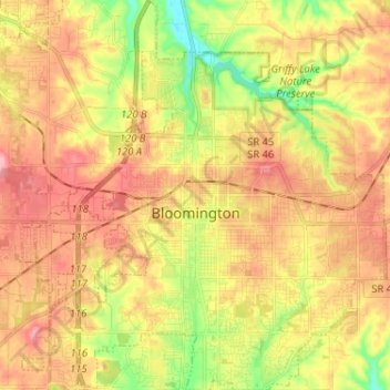
Nombre: Mapa topográfico Bloomington, altitud, relieve.
Lugar: Bloomington, Monroe County, Indiana, United States (39.12133 -86.59189 39.22136 -86.47113)
Altitud media: 241 m
Altitud mínima: 177 m
Altitud máxima: 293 m
Bloomington is an area of irregular limestone terrain characterized by sinks, ravines, fissures, underground streams, sinking streams, springs and caves. It is in the rolling hills of southern Indiana, resting on the intersection of the Norman Uplands and the Mitchell Plain. The city's relatively varied topography is a sharp contrast to the flatter terrain more typical of central to northern portions of Indiana.
Otros mapas topográficos
Haga clic en un mapa para ver su topografía, su altitud y su relieve.
Ellettsville
United States > Indiana > Monroe County > Ellettsville
Ellettsville, Monroe County, Indiana, United States
Altitud media: 235 m