
Mapa topográfico Cowichan River
Mapa interactivo
Haga clic en el mapa para ver la altitud.
Acerca de este mapa
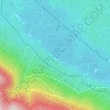
Nombre: Mapa topográfico Cowichan River, altitud, relieve.
Altitud media: 250 m
Altitud mínima: 119 m
Altitud máxima: 717 m
Otros mapas topográficos
Haga clic en un mapa para ver su topografía, su altitud y su relieve.
Carmanah Walbran Provincial Park
Canada > British Columbia > Area F (Cowichan Lake South / Skutz Falls)
Carmanah Walbran Provincial Park, Area F (Cowichan Lake South / Skutz Falls), Cowichan Valley Regional District, British Columbia, Canada
Altitud media: 365 m
Josiah Creek
Canada > British Columbia > Area F (Cowichan Lake South / Skutz Falls)
Josiah Creek, Area F (Cowichan Lake South / Skutz Falls), Cowichan Valley Regional District, British Columbia, V0R 2G0, Canada
Altitud media: 220 m
Nitinat River Provincial Park
Canada > British Columbia > Area F (Cowichan Lake South / Skutz Falls)
Nitinat River Provincial Park, Cowichan Main, Upper Nitinat River Woodlands, Area F (Cowichan Lake South / Skutz Falls), Cowichan Valley Regional District, British Columbia, Canada
Altitud media: 361 m