
Mapa topográfico Patras
Mapa interactivo
Haga clic en el mapa para ver la altitud.
Acerca de este mapa
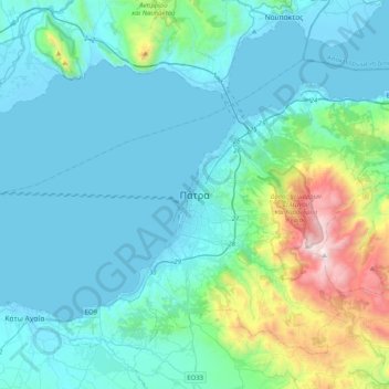
Nombre: Mapa topográfico Patras, altitud, relieve.
Altitud media: 283 m
Altitud mínima: -5 m
Altitud máxima: 1.918 m
A central feature of the urban geography of Patras is its division into upper and lower sections. This is the result of an interplay between natural geography and human settlement patterns; the lower section of the city (Kato Poli), which includes the 19th-century urban core and the port, is adjacent to the sea and stretches between the estuaries of the rivers of Glafkos and Haradros. It is built on what was originally a bed of river soils and dried-up swamps. The older upper section (Ano Poli) covers the area of the pre-modern settlement, around the Fortress, on what is the last elevation of Mount Panachaikon (1,926 m (6,319 ft)) before the Gulf of Patras.
Otros mapas topográficos
Haga clic en un mapa para ver su topografía, su altitud y su relieve.
Aigio
Greece > Peloponnese, Western Greece and the Ionian > Achaia Regional Unit
Aigio, Municipal Unit of Aegio, Municipality of Aigialeia, Achaia Regional Unit, Western Greece, Peloponnese, Western Greece and the Ionian, 251 00, Greece
Altitud media: 371 m
Municipality of Patras
Greece > Peloponnese, Western Greece and the Ionian > Achaia Regional Unit
Municipality of Patras, Achaia Regional Unit, Western Greece, Peloponnese, Western Greece and the Ionian, Greece
Altitud media: 291 m