
Mapa topográfico Vietnam
Mapa interactivo
Haga clic en el mapa para ver la altitud.
Acerca de este mapa
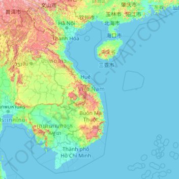
Nombre: Mapa topográfico Vietnam, altitud, relieve.
Lugar: Vietnam (7.69209 102.14386 23.39269 114.85726)
Altitud media: 173 m
Altitud mínima: -3 m
Altitud máxima: 2.808 m
Due to differences in latitude and the marked variety in topographical relief, Vietnam's climate tends to vary considerably for each region. Vietnam is a country located in the tropics, however Northern Vietnam, including Hanoi, is considered a subtropical region by Köppen climate classification. During the winter or dry season, extending roughly from November to April, the monsoon winds usually blow from the northeast along the Chinese coast and across the Gulf of Tonkin, picking up considerable moisture. The average annual temperature is generally higher in the plains than in the mountains, especially in southern Vietnam compared to the north. Temperatures vary less in the southern plains around Ho Chi Minh City and the Mekong Delta, ranging from between 21 and 35 °C (69.8 and 95.0 °F) over the year. In Hanoi and the surrounding areas of Red River Delta, the temperatures are much lower between 15 and 33 °C (59.0 and 91.4 °F). Seasonal variations in the mountains, plateaus, and the northernmost areas are much more dramatic, with temperatures varying from 3 °C (37.4 °F) in December and January to 37 °C (98.6 °F) in July and August. During winter, snow occasionally falls over the highest peaks of the far northern mountains near the Chinese border. Vietnam receives high rates of precipitation in the form of rainfall with an average amount from 1,500 mm (59 in) to 2,000 mm (79 in) during the monsoon seasons; this often causes flooding, especially in the cities with poor drainage systems. The country is also affected by tropical depressions, tropical storms and typhoons. Vietnam is one of the most vulnerable countries to climate change, with 55% of its population living in low-elevation coastal areas.
Otros mapas topográficos
Haga clic en un mapa para ver su topografía, su altitud y su relieve.
Rímac
Perú > Lima > Lima Metropolitana
Rímac, Lima, Lima Metropolitana, Lima, Perú
Altitud media: 198 m
Jesús María
Perú > Lima > Lima Metropolitana
Jesús María, Lima, Lima Metropolitana, Lima, 15072, Perú
Altitud media: 110 m
Santiago de Surco
Perú > Lima > Lima Metropolitana
Santiago de Surco, Lima, Lima Metropolitana, Lima, Perú
Altitud media: 171 m
Los Olivos
Perú > Lima > Lima Metropolitana
Los Olivos, Lima, Lima Metropolitana, Lima, Perú
Altitud media: 142 m
Lurín
Perú > Lima > Lima Metropolitana
Lurín, Lima, Lima Metropolitana, Lima, Perú
Altitud media: 514 m
La Victoria
Perú > Lima > Lima Metropolitana
La Victoria, Lima, Lima Metropolitana, Lima, Perú
Altitud media: 155 m
Chorrillos
Perú > Lima > Lima Metropolitana
Chorrillos, Lima, Lima Metropolitana, Lima, Perú
Altitud media: 34 m
Chile
Chile
Altitud media: 193 m
Refugio de Vida Silvestre Los Pantanos de Villa
Perú > Lima > Chorrillos
Refugio de Vida Silvestre Los Pantanos de Villa, Avenida Caminos del Inca, Los Huertos de Villa, Chorrillos, Lima, 15067, Perú
Altitud media: 10 m
San Martin de Porres
Perú > Tacna > La Yarada-Los Palos
San Martin de Porres, La Yarada-Los Palos, Tacna, Perú
Altitud media: 51 m
Ventanilla
Ventanilla, Lima Metropolitana, Callao, 07051, Perú
Altitud media: 126 m
San Borja
Perú > Lima > Lima Metropolitana
San Borja, Lima, Lima Metropolitana, Lima, Perú
Altitud media: 162 m
San Juan de Lurigancho
Perú > Lima > Lima Metropolitana
San Juan de Lurigancho, Lima, Lima Metropolitana, Lima, Perú
Altitud media: 541 m
Cieneguilla
Perú > Lima > Lima Metropolitana
Cieneguilla, Lima, Lima Metropolitana, Lima, Perú
Altitud media: 879 m
Comas
Perú > Lima > Lima Metropolitana
Comas, Lima, Lima Metropolitana, Lima, Perú
Altitud media: 273 m
Villa El Salvador
Perú > Lima > Lima Metropolitana
Villa El Salvador, Lima, Lima Metropolitana, Lima, Perú
Altitud media: 104 m
Parque Arqueológico Nacional de Tipón
Perú > Cusco > Oropesa > Choccepata / Pitupuggio
Parque Arqueológico Nacional de Tipón, Choccepata / Pitupuggio, Oropesa, Quispicanchi, Cusco, Perú
Altitud media: 3.472 m
Palmanova
Italia > Friuli-Venecia Julia > Údine
Palmanova, Údine, Friuli-Venecia Julia, 33057, Italia
Altitud media: 28 m
Villa María del Triunfo
Perú > Lima > Lima Metropolitana
Villa María del Triunfo, Lima, Lima Metropolitana, Lima, Perú
Altitud media: 275 m
San Martín de Porres
Perú > Lima > Lima Metropolitana
San Martín de Porres, Lima, Lima Metropolitana, Lima, Perú
Altitud media: 55 m
Ancón
Perú > Lima > Lima Metropolitana
Ancón, Lima, Lima Metropolitana, Lima, Perú
Altitud media: 542 m
Chasquitambo
Perú > Áncash > Chasquitambo
Chasquitambo, Provincia de Bolognesi, Áncash, Perú
Altitud media: 967 m