
Mapa topográfico Christmas Island
Mapa interactivo
Haga clic en el mapa para ver la altitud.
Acerca de este mapa
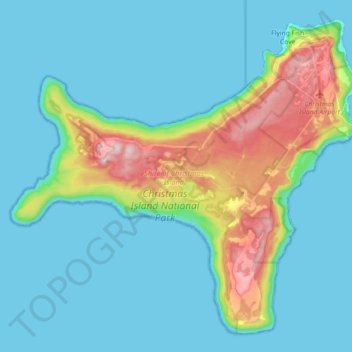
Nombre: Mapa topográfico Christmas Island, altitud, relieve.
Altitud media: 69 m
Altitud mínima: 0 m
Altitud máxima: 363 m
Steep cliffs along much of the coast rise abruptly to a central plateau. Elevation ranges from sea level to 361 m (1,184 ft) at Murray Hill. The island is mainly tropical rainforest, 63% of which is national parkland. The narrow fringing reef surrounding the island poses a maritime hazard.