
Mapa topográfico Inman Valley
Mapa interactivo
Haga clic en el mapa para ver la altitud.
Acerca de este mapa
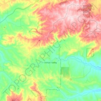
Nombre: Mapa topográfico Inman Valley, altitud, relieve.
Altitud media: 212 m
Altitud mínima: 49 m
Altitud máxima: 443 m
In the valley is Selwyn Rock (35°29′47″S 138°30′45″E / 35.4965°S 138.5124°E / -35.4965; 138.5124) a glaciated pavement in the bed of the Inman River. It was first described in 1859 by, and later named for, A.R.C. Selwyn,[17] who was Victorian Government geologist at the time. Glacial grooves and striations on the polished surface indicate glacial movement to the north-west. Boulder clays, tillites and erratics are also common in the area, which underwent glaciation during the Permian (approximately 270 Ma). The pavement was exposed during the Tertiary when the Inman River eroded the topography to its present-day surface. A cafe overlooks the glaciated bed of the river, with access onto the rock available via stairs and viewing platforms.
Otros mapas topográficos
Haga clic en un mapa para ver su topografía, su altitud y su relieve.
Bald Hills
Australia > South Australia > The District Council of Yankalilla
Bald Hills, The District Council of Yankalilla, South Australia, 5203, Australia
Altitud media: 162 m
Myponga Beach
Australia > South Australia > The District Council of Yankalilla
Myponga Beach, The District Council of Yankalilla, South Australia, 5202, Australia
Altitud media: 110 m
Kalumunda Forest Reserve
Australia > South Australia > The District Council of Yankalilla
Kalumunda Forest Reserve, Hay Flat, The District Council of Yankalilla, South Australia, 5204, Australia
Altitud media: 265 m
Deep Creek Conservation Park
Australia > South Australia > The District Council of Yankalilla
Deep Creek Conservation Park, Deep Creek, The District Council of Yankalilla, South Australia, 5204, Australia
Altitud media: 183 m
Yankalilla
Australia > South Australia > The District Council of Yankalilla
Yankalilla, The District Council of Yankalilla, South Australia, 5203, Australia
Altitud media: 104 m
Myponga River
Australia > South Australia > The District Council of Yankalilla > Myponga > Myponga Beach
Myponga River, Myponga Beach, Myponga, The District Council of Yankalilla, South Australia, 5202, Australia
Altitud media: 138 m
Myponga
Australia > South Australia > The District Council of Yankalilla
Myponga, The District Council of Yankalilla, South Australia, 5202, Australia
Altitud media: 246 m
Second Valley
Australia > South Australia > The District Council of Yankalilla
Second Valley, The District Council of Yankalilla, South Australia, 5204, Australia
Altitud media: 173 m
Normanville
Australia > South Australia > The District Council of Yankalilla
Normanville, The District Council of Yankalilla, South Australia, 5204, Australia
Altitud media: 64 m
Carrickalinga
Australia > South Australia > The District Council of Yankalilla
Carrickalinga, The District Council of Yankalilla, South Australia, 5204, Australia
Altitud media: 53 m
Rapid Bay
Australia > South Australia > The District Council of Yankalilla
Rapid Bay, The District Council of Yankalilla, South Australia, 5204, Australia
Altitud media: 104 m
Cape Jervis
Australia > South Australia > The District Council of Yankalilla
Cape Jervis, The District Council of Yankalilla, South Australia, 5204, Australia
Altitud media: 73 m
Wirrina Cove
Australia > South Australia > The District Council of Yankalilla
Wirrina Cove, The District Council of Yankalilla, South Australia, 5204, Australia
Altitud media: 43 m