
Haz una donación
Mapa topográfico Innisfail
Haga clic en el mapa para ver la altitud.
Haz una donación
Acerca de este mapa
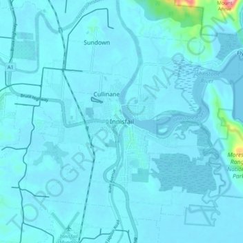
Nombre: Mapa topográfico Innisfail, altitud, relieve.
Altitud media: 12 m
Altitud mínima: -2 m
Altitud máxima: 233 m
Haz una donación
Otros mapas topográficos
Haga clic en un mapa para ver su topografía, su altitud y su relieve.
Lama Lama National Park (Cape York Peninsula Aboriginal Land)
Altitud media: 86 m
City of Brisbane
Brisbane's topography is characterized by a series of hills and ranges that define its landscape. The city is situated on a low-lying floodplain, with the Brisbane River meandering through its heart, creating a winding course with many steep curves from the southwest to its mouth at Moreton Bay in the east.…
Altitud media: 71 m
Haz una donación
Haz una donación
Brisbane River
The RAAF also perform a practice session in the days preceding the event, serving as an opportunity to both practice beforehand and also promote Riverfire. One of the most popular RAAF aircraft to perform at Riverfire was the F-111 which was known for performing a 'dump-and-burn' above the city. The final…
Altitud media: 235 m
Haz una donación
Haz una donación
Haz una donación
Sunshine Coast Regional
The Sunshine Coast Regional area in Queensland, Australia, features a diverse topography that ranges from coastal plains to rugged hinterlands. Along the coastline, the terrain is predominantly flat, with average elevations around 20 meters (66 feet) above sea level. Inland, the landscape transitions to…
Altitud media: 56 m
Haz una donación
Lamb Island
Australia > Queensland > Brisbane
The island is in the southern part of Moreton Bay between the Queensland mainland and North Stradbroke Island. It is within the Moreton Bay Marine Park. The elevation ranges from 0 to 26 metres (0 to 85 ft) above sea level. The land use on the island is predominantly residential.
Altitud media: 4 m
City of Brisbane
Brisbane's topography is characterized by a series of hills and ranges that define its landscape. The city is situated on a low-lying floodplain, with the Brisbane River meandering through its heart, creating a winding course with many steep curves from the southwest to its mouth at Moreton Bay in the east.…
Altitud media: 71 m
Haz una donación
Haz una donación
Haz una donación
Haz una donación
Haz una donación
Haz una donación
Haz una donación
Haz una donación
Haz una donación
Haz una donación
Haz una donación
Haz una donación
Haz una donación
Haz una donación
Haz una donación
Haz una donación
Haz una donación
Haz una donación
Haz una donación