
Mapa topográfico Portland
Mapa interactivo
Haga clic en el mapa para ver la altitud.
Acerca de este mapa
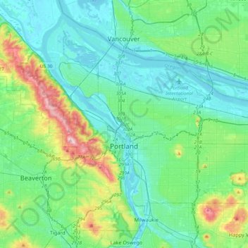
Nombre: Mapa topográfico Portland, altitud, relieve.
Lugar: Portland, Multnomah County, Oregon, United States (45.43254 -122.83675 45.65288 -122.47203)
Altitud media: 77 m
Altitud mínima: -5 m
Altitud máxima: 382 m
Annual snowfall in Portland is 4.3 inches (10.9 cm), which usually falls during the December-to-March time frame. The city of Portland avoids snow more frequently than its suburbs, due in part to its low elevation and urban heat island effect. Neighborhoods outside of the downtown core, especially in slightly higher elevations near the West Hills and Mount Tabor, can experience a dusting of snow while downtown receives no accumulation at all. The city has experienced a few major snow and ice storms in its past with extreme totals having reached 44.5 in (113 cm) at the airport in 1949–50 and 60.9 in (155 cm) at downtown in 1892–93.
Otros mapas topográficos
Haga clic en un mapa para ver su topografía, su altitud y su relieve.
Corbett
United States > Oregon > Multnomah County
Corbett, Multnomah County, Oregon, 97019, United States
Altitud media: 127 m
Sauvie Island
United States > Oregon > Multnomah County
Sauvie Island, Multnomah County, Oregon, United States
Altitud media: 157 m
Troutdale
United States > Oregon > Multnomah County
Troutdale, Multnomah County, Oregon, 97060, United States
Altitud media: 54 m
Gresham
United States > Oregon > Multnomah County
Gresham, Multnomah County, Oregon, United States
Altitud media: 90 m
East Columbia
United States > Oregon > Multnomah County > Portland
East Columbia, Portland, Multnomah County, Oregon, United States
Altitud media: 9 m