
Mapa topográfico Mount Saint Helens
Mapa interactivo
Haga clic en el mapa para ver la altitud.
Acerca de este mapa
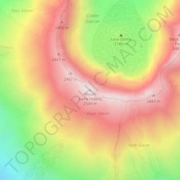
Nombre: Mapa topográfico Mount Saint Helens, altitud, relieve.
Altitud media: 2.096 m
Altitud mínima: 1.540 m
Altitud máxima: 2.533 m
The Mount St. Helens major eruption of May 18, 1980 remains the deadliest and most economically destructive volcanic event in U.S. history. Fifty-seven people were killed; 200 homes, 47 bridges, 15 miles (24 km) of railways, and 185 miles (298 km) of highway were destroyed. A massive debris avalanche, triggered by a magnitude 5.1 earthquake, caused a lateral eruption that reduced the elevation of the mountain's summit from 9,677 ft (2,950 m) to 8,363 ft (2,549 m), leaving a 1 mile (1.6 km) wide horseshoe-shaped crater. The debris avalanche was 0.6 cubic miles (2.5 km3) in volume. The 1980 eruption disrupted terrestrial ecosystems near the volcano. By contrast, aquatic ecosystems in the area greatly benefited from the amounts of ash, allowing life to multiply rapidly. Six years after the eruption, most lakes in the area had returned to their normal state.
Otros mapas topográficos
Haga clic en un mapa para ver su topografía, su altitud y su relieve.
Gifford Pinchot National Forest
United States > Washington > Skamania County
Gifford Pinchot National Forest, Skamania County, Washington, United States
Altitud media: 769 m
Spirit Lake
United States > Washington > Skamania County
Spirit Lake, Skamania County, Washington, United States
Altitud media: 1.144 m