
Mapa topográfico Galicia
Mapa interactivo
Haga clic en el mapa para ver la altitud.
Acerca de este mapa
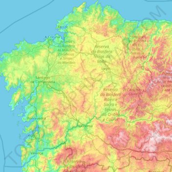
Nombre: Mapa topográfico Galicia, altitud, relieve.
Lugar: Galicia, Spain (41.80736 -9.30154 43.79042 -6.73395)
Altitud media: 456 m
Altitud mínima: -2 m
Altitud máxima: 2.088 m
The interior of Galicia is characterized by a hilly landscape; mountain ranges rise to 2,000 m (6,600 ft) in the east and south. The coastal areas are mostly an alternate series of rias and beaches. The climate of Galicia is usually temperate and rainy, with markedly drier summers; it is usually classified as Oceanic. Its topographic and climatic conditions have made animal husbandry and farming the primary source of Galicia's wealth for most of its history, allowing for a relatively high density of population. Except shipbuilding and food processing, Galicia was based on a farming and fishing economy until after the mid-20th century, when it began to industrialize. In 2018, the nominal gross domestic product was €62.900 billion, with a nominal GDP per capita of €23,300. Galicia is characterised, unlike other Spanish regions, by the absence of a metropolis dominating the territory. Indeed, the urban network is made up of 7 main cities (the four provincial capitals A Coruña, Pontevedra, Ourense and Lugo, the political capital Santiago de Compostela and the industrial cities Vigo and Ferrol and other small towns. The population is largely concentrated in two main areas: from Ferrol to A Coruña on the northern coast, and in the Rías Baixas region in the southwest, including the cities of Vigo, Pontevedra, and the interior city of Santiago de Compostela. There are smaller populations around the interior cities of Lugo and Ourense. The political capital is Santiago de Compostela, in the province of A Coruña. Vigo, in the province of Pontevedra, is the largest municipality in Galicia and also the most populated city. Two languages are official and widely used today in Galicia: the native Galician, a Romance language closely related to Portuguese with which it shares the Galician-Portuguese medieval literature; and Spanish, usually called Castilian. While most Galicians are bilingual, a 2013 survey reported that 51% of the Galician population spoke Galician most often on a day-to-day basis, while 48% most often used Spanish.
Otros mapas topográficos
Haga clic en un mapa para ver su topografía, su altitud y su relieve.
Valle de Benasque
Valle de Benasque, Benasque, Ribagorza, Aragon, Spain
Altitud media: 2.091 m
Santa Marta de Tormes
Santa Marta de Tormes, Salamanca, Castile and León, Spain
Altitud media: 799 m
Cuarterón
Spain > Rioja > Cervera del Río Alhama
Cuarterón, Cervera del Río Alhama, Rioja, Spain
Altitud media: 720 m
Tàrbena
Tàrbena, la Marina Baixa, Alacant / Alicante, Valencian Community, Spain
Altitud media: 571 m
Cantón
Spain > Region of Murcia > Oriental > Abanilla
Cantón, Abanilla, Oriental, Region of Murcia, Spain
Altitud media: 555 m
Los Llanos de Aridane
Los Llanos de Aridane, Santa Cruz de Tenerife, Canary Islands, Spain
Altitud media: 357 m
Jimena de la Frontera
Spain > Andalusia > Campo de Gibraltar
Jimena de la Frontera, Campo de Gibraltar, Cádiz, Andalusia, 11339, Spain
Altitud media: 269 m
Alba de Cerrato
Alba de Cerrato, Palencia, Castile and León, 34219, Spain
Altitud media: 827 m
La Nogada
Spain > Castile and León > Cardeñuela Riopico
La Nogada, Cardeñuela Riopico, Burgos, Castile and León, 09198, Spain
Altitud media: 1.004 m
Cadalso de los Vidrios
Cadalso de los Vidrios, Community of Madrid, Spain
Altitud media: 769 m
Allariz
Spain > Galicia > Allariz-Maceda
Allariz, Allariz-Maceda, Ourense, Galicia, Spain
Altitud media: 580 m
Erill la Vall
Spain > Catalonia > Alta Ribagorça > la Vall de Boí > Boí
Erill la Vall, Boí, la Vall de Boí, Alta Ribagorça, Catalonia, 25528, Spain
Altitud media: 1.599 m
Sabadell
Spain > Catalonia > Vallès Occidental
Sabadell, Vallès Occidental, Barcelona, Catalonia, Spain
Altitud media: 183 m
Murcia
Spain > Region of Murcia > Área Metropolitana de Murcia
Murcia, Área Metropolitana de Murcia, Region of Murcia, Spain
Altitud media: 171 m
Santa Ponsa
Spain > Balearic Islands > Serra de Tramuntana
Santa Ponsa, Calvià, Serra de Tramuntana, Balearic Islands, 07180, Spain
Altitud media: 41 m
Vilagarcía de Arousa
Vilagarcía de Arousa, O Salnés, Pontevedra, Galicia, Spain
Altitud media: 71 m
l'Hospitalet de Llobregat
Spain > Catalonia > Barcelonès
l'Hospitalet de Llobregat, Barcelonès, Barcelona, Catalonia, Spain
Altitud media: 31 m
Villaverde de Medina
Villaverde de Medina, Valladolid, Castile and León, 47465, Spain
Altitud media: 744 m
Fuente Pila
Spain > Community of Madrid > Navalcarnero
Fuente Pila, Navalcarnero, Community of Madrid, 28600, Spain
Altitud media: 631 m
Tordesillas
Tordesillas, Valladolid, Castile and León, Spain
Altitud media: 733 m
Carballo
Spain > Galicia > Bergantiños
Carballo, Bergantiños, A Coruña, Galicia, 15102, Spain
Altitud media: 144 m
Cala d'Or
Spain > Balearic Islands > Migjorn > Santanyí
Cala d'Or, Santanyí, Migjorn, Balearic Islands, 07660, Spain
Altitud media: 17 m
Zizurkil
Spain > Autonomous Community of the Basque Country
Zizurkil, Gipuzkoa, Autonomous Community of the Basque Country, 20159, Spain
Altitud media: 217 m
Sueca
Sueca, la Ribera Baixa, Valencia, Valencian Community, Spain
Altitud media: 4 m
Albox
Spain > Andalusia > Valle del Almanzora
Albox, Valle del Almanzora, Almeria, Andalusia, 04800, Spain
Altitud media: 707 m
Cabana de Bergantiños
Spain > Galicia > Bergantiños
Cabana de Bergantiños, Bergantiños, A Coruña, Galicia, Spain
Altitud media: 169 m
Langa de Duero
Langa de Duero, Soria, Castile and León, Spain
Altitud media: 941 m