
Mapa topográfico Silver City
Mapa interactivo
Haga clic en el mapa para ver la altitud.
Acerca de este mapa
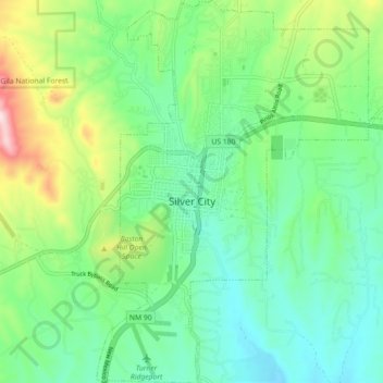
Nombre: Mapa topográfico Silver City, altitud, relieve.
Altitud media: 1.850 m
Altitud mínima: 1.733 m
Altitud máxima: 2.135 m
During the period from 1901 to 1964 when readings were taken at the city center (which is cooler and wetter than outlying and lower-elevation districts nearby), the coldest temperature recorded was −13 °F (−25 °C) on January 11, 1962, and the hottest 105 °F (40.6 °C) on July 5, 1901. The coldest month was January 1949 with a monthly mean temperature of 28.7 °F or −1.8 °C, and the hottest July 1951 which averaged 77.4 °F or 25.2 °C. The wettest calendar year in this time span was 1914 with 24.97 inches or 634.2 millimetres and the driest 1947 with 6.77 inches or 172.0 millimetres. The most snow in one season was 48.0 inches or 1.22 metres between July 1912 and June 1913, which featured the coldest winter on record with 33.1 °F or 0.6 °C as the mean from December to February.
Otros mapas topográficos
Haga clic en un mapa para ver su topografía, su altitud y su relieve.
Basin and Range Country Historical Marker
United States > New Mexico > Grant County
Basin and Range Country Historical Marker, Grant County, New Mexico, United States
Altitud media: 1.393 m