
Mapa topográfico Σμόλικας
Mapa interactivo
Haga clic en el mapa para ver la altitud.
Acerca de este mapa
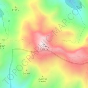
Nombre: Mapa topográfico Σμόλικας, altitud, relieve.
Altitud media: 2.199 m
Altitud mínima: 1.808 m
Altitud máxima: 2.607 m
Mount Smolikas (Greek: Σμόλικας; Aromanian: Smolcu) is a mountain in the Ioannina regional unit, northwestern Greece. At a height of 2,637 metres above sea level, it is the highest of the Pindus Mountains, and the second highest mountain in Greece after Mount Olympus. The mountain consists of ophiolite rocks. During several periods in the Pleistocene the northern and eastern cirques and valleys were glaciated. The last glaciers of this area retreated around 11,500 years ago. It is drained by the river Vjosa to the south, and the river Vourkopotamo (a tributary of the Sarantaporos) to the north. There is a small alpine lake called "Drakolimni Smolika" near the summit, at about 2,200 metres elevation. Nearby mountain ranges are Tymfi to the south, Gramos to the northwest, Vasilitsa to the southeast and Voio to the northeast.
Otros mapas topográficos
Haga clic en un mapa para ver su topografía, su altitud y su relieve.
Ioannina
Greece > Epirus and Western Macedonia > Ioannina Regional Unit
Ioannina, Ioannina Municipality, Ioannina Regional Unit, Epirus, Epirus and Western Macedonia, Greece
Altitud media: 493 m
Μικρό Πάπιγκο
Greece > Epirus and Western Macedonia > Ioannina Regional Unit
Μικρό Πάπιγκο, Zagori Municipality, Ioannina Regional Unit, Epirus, Epirus and Western Macedonia, 440 04, Greece
Altitud media: 1.237 m
Παρακάλαμος
Greece > Epirus and Western Macedonia > Ioannina Regional Unit
Παρακάλαμος, Pogoni Municipality, Ioannina Regional Unit, Epirus, Epirus and Western Macedonia, 440 04, Greece
Altitud media: 416 m
Kalpaki
Greece > Epirus and Western Macedonia > Ioannina Regional Unit
Kalpaki, Dodoni Municipality, Ioannina Regional Unit, Epirus, Epirus and Western Macedonia, Greece
Altitud media: 1.068 m
Ioannina
Greece > Epirus and Western Macedonia > Ioannina Regional Unit
Ioannina, Ioannina Municipality, Ioannina Regional Unit, Epirus, Epirus and Western Macedonia, 453 33, Greece
Altitud media: 724 m
Καστανιά
Greece > Epirus and Western Macedonia > Ioannina Regional Unit
Καστανιά, Konitsa Municipality, Ioannina Regional Unit, Epirus, Epirus and Western Macedonia, 440 15, Greece
Altitud media: 1.069 m
Μέτσοβο
Greece > Epirus and Western Macedonia > Ioannina Regional Unit
Μέτσοβο, Metsovo Municipality, Ioannina Regional Unit, Epirus, Epirus and Western Macedonia, 442 00, Greece
Altitud media: 1.318 m
Βραδέτο
Greece > Epirus and Western Macedonia > Ioannina Regional Unit > Καπέσοβο > Βραδέτο
Βραδέτο, Καπέσοβο, Zagori Municipality, Ioannina Regional Unit, Epirus, Epirus and Western Macedonia, 44018, Greece
Altitud media: 1.174 m
Perama
Greece > Epirus and Western Macedonia > Ioannina Regional Unit > Perama Municipal Unit
Perama, Perama Municipal Unit, Ioannina Municipality, Ioannina Regional Unit, Epirus, Epirus and Western Macedonia, 455 00, Greece
Altitud media: 653 m