
Mapa topográfico San Leandro
Mapa interactivo
Haga clic en el mapa para ver la altitud.
Acerca de este mapa
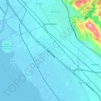
Nombre: Mapa topográfico San Leandro, altitud, relieve.
Altitud media: 21 m
Altitud mínima: -5 m
Altitud máxima: 238 m
The San Leandro Hills run above the city to the northeast. In the lower elevations of the city, an upper regionally contained aquifer is located 50 to 100 feet (15 to 30 m) below the surface. At least one deeper aquifer exists approximately 250 feet (75 m) below the surface. Some salt water intrusion has taken place in the San Leandro Cone. Shallow groundwater generally flows to the west, from the foothills toward San Francisco Bay. Shallow groundwater is contaminated in many of the locales of the lower elevation of the city. Contamination by gasoline, volatile organic compounds and some heavy metals has been recorded in a number of these lower-elevation areas.
Otros mapas topográficos
Haga clic en un mapa para ver su topografía, su altitud y su relieve.
Sorenson
United States > California > Alameda County > Hayward
Sorenson, Hayward, Alameda County, California, 94544, United States
Altitud media: 55 m
Hayward
United States > California > Alameda County
Hayward, Alameda County, California, United States
Altitud media: 77 m
Piedmont
United States > California > Alameda County > Piedmont
Piedmont, Alameda County, California, 94611, United States
Altitud media: 97 m