
Mapa topográfico Messines
Mapa interactivo
Haga clic en el mapa para ver la altitud.
Acerca de este mapa
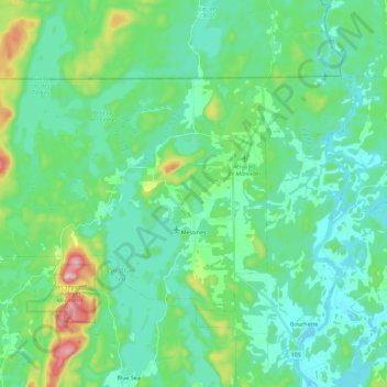
Nombre: Mapa topográfico Messines, altitud, relieve.
Altitud media: 193 m
Altitud mínima: 140 m
Altitud máxima: 391 m
Otros mapas topográficos
Haga clic en un mapa para ver su topografía, su altitud y su relieve.
Low
Canada > Quebec > La Vallée-de-la-Gatineau
Low, La Vallée-de-la-Gatineau, Outaouais, Quebec, J0X 2C0, Canada
Altitud media: 220 m
Blue Sea
Canada > Quebec > La Vallée-de-la-Gatineau > Blue Sea
Blue Sea, La Vallée-de-la-Gatineau, Outaouais, Quebec, J0X 1C0, Canada
Altitud media: 203 m
Lac-Sainte-Marie
Canada > Quebec > La Vallée-de-la-Gatineau
Lac-Sainte-Marie, La Vallée-de-la-Gatineau, Outaouais, Quebec, J0X 1Z0, Canada
Altitud media: 206 m