
Mapa topográfico Lake Como
Mapa interactivo
Haga clic en el mapa para ver la altitud.
Acerca de este mapa
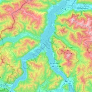
Nombre: Mapa topográfico Lake Como, altitud, relieve.
Lugar: Lake Como, Como, Lombardy, Italy (45.81316 9.06673 46.17036 9.38897)
Altitud media: 885 m
Altitud mínima: 188 m
Altitud máxima: 2.593 m
Lake Como weather is humid subtropical (Cfa in the Köppen climate classification). In winter, the lake helps to maintain a higher temperature in the surrounding region. Average daily temperatures range from ~3.7 °C (39 °F) in January to 23.4 °C (74 °F) in July, according to historical weather data from Como. Water temperatures can reach an average of 24 °C (75 °F) in July. Snowfall is erratic and is mainly at higher elevations. Rainfall is heaviest in May and lowest during the winter months.
Otros mapas topográficos
Haga clic en un mapa para ver su topografía, su altitud y su relieve.
San Fedele Intelvi
San Fedele Intelvi, Centro Valle Intelvi, Como, Lombardy, 22028, Italy
Altitud media: 828 m
Naggio
Italy > Lombardy > Como > Grandola ed Uniti
Naggio, Grandola ed Uniti, Como, Lombardy, 22010, Italy
Altitud media: 651 m
San Giorgio
Italy > Lombardy > Como > Solbiate con Cagno > Concagno
San Giorgio, Concagno, Solbiate con Cagno, Como, Lombardy, 22043, Italy
Altitud media: 400 m
Casasco d'Intelvi
Casasco d'Intelvi, Centro Valle Intelvi, Como, Lombardy, 22023, Italy
Altitud media: 853 m
Campione d'Italia
Italy > Lombardy > Como > Campione d'Italia
Campione d'Italia, Como, Lombardy, Italy
Altitud media: 438 m
Montemezzo
Italy > Lombardy > Como > Montemezzo
Montemezzo, Como, Lombardy, Italy
Altitud media: 1.156 m