
Mapa topográfico Somerset
Mapa interactivo
Haga clic en el mapa para ver la altitud.
Acerca de este mapa
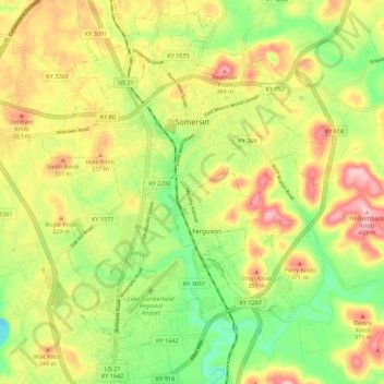
Nombre: Mapa topográfico Somerset, altitud, relieve.
Lugar: Somerset, Pulaski County, Kentucky, 42503, United States (37.03135 -84.64756 37.12006 -84.56484)
Altitud media: 295 m
Altitud mínima: 202 m
Altitud máxima: 398 m
Somerset is located at 37°4′59″N 84°36′34″W / 37.08306°N 84.60944°W / 37.08306; -84.60944 (37.082966, −84.609387), and the downtown (central) part of the city is at an elevation of 974 feet above sea level. The city is located at the eastern end of Kentucky's Mississippian Plateau (or Pennyroyal Plateau); however, the micropolitan area extends eastward into the Appalachian Plateau (or Eastern Kentucky Coalfield), and northward to Kentucky's Outer Bluegrass region. Thus, the area shows variations in landforms and scenery.
Otros mapas topográficos
Haga clic en un mapa para ver su topografía, su altitud y su relieve.
Sinking Valley
United States > Kentucky > Pulaski County
Sinking Valley, Pulaski County, Kentucky, United States
Altitud media: 309 m
Eubank
United States > Kentucky > Pulaski County
Eubank, Pulaski County, Kentucky, United States
Altitud media: 354 m
Oil Center
United States > Kentucky > Pulaski County
Oil Center, Pulaski County, Kentucky, United States
Altitud media: 268 m
Burnside
United States > Kentucky > Pulaski County
Burnside, Pulaski County, Kentucky, United States
Altitud media: 251 m
Science Hill
United States > Kentucky > Pulaski County
Science Hill, Pulaski County, Kentucky, United States
Altitud media: 327 m
Elrod
United States > Kentucky > Pulaski County > Elrod
Elrod, Pulaski County, Kentucky, United States
Altitud media: 298 m
Keno
United States > Kentucky > Pulaski County
Keno, Pulaski County, Kentucky, United States
Altitud media: 308 m