
Mapa topográfico Bastogne
Mapa interactivo
Haga clic en el mapa para ver la altitud.
Acerca de este mapa
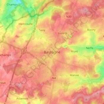
Nombre: Mapa topográfico Bastogne, altitud, relieve.
Lugar: Bastogne, Luxembourg, Wallonia, 6600, Belgium (49.96231 5.67734 50.04231 5.75734)
Altitud media: 505 m
Altitud mínima: 413 m
Altitud máxima: 562 m
The municipality consists of the following districts: Bastogne, Longvilly, Noville, Villers-la-Bonne-Eau, and Wardin. The town is situated on a ridge in the Ardennes at an elevation of 510 metres (1,670 ft).
Otros mapas topográficos
Haga clic en un mapa para ver su topografía, su altitud y su relieve.
Foy
Belgium > Luxembourg > Bastogne > Bastogne
Foy, Bastogne, Luxembourg, Wallonia, Belgium
Altitud media: 506 m
Bras
Belgium > Luxembourg > Bastogne > Bastogne
Bras, Bastogne, Luxembourg, Wallonia, Belgium
Altitud media: 470 m