
Mapa topográfico Big Sky
Mapa interactivo
Haga clic en el mapa para ver la altitud.
Acerca de este mapa
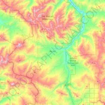
Nombre: Mapa topográfico Big Sky, altitud, relieve.
Lugar: Big Sky, Gallatin County, Montana, United States (45.13076 -111.49439 45.37939 -111.03817)
Altitud media: 2.435 m
Altitud mínima: 1.689 m
Altitud máxima: 3.382 m
This climatic region is typified by large seasonal temperature differences, with warm to hot summers and cold (sometimes severely cold) winters. According to the Köppen Climate Classification system, Big Sky has a borderline humid continental (Dfb) / alpine subarctic climate (Dfc). for most of the area, but the lower elevations may be closer to a dry continental climate.
Otros mapas topográficos
Haga clic en un mapa para ver su topografía, su altitud y su relieve.
Logan
United States > Montana > Gallatin County
Logan, Gallatin County, Montana, United States
Altitud media: 1.294 m
Bozeman
United States > Montana > Gallatin County
Bozeman, Gallatin County, Montana, United States
Altitud media: 1.495 m
Three Forks
United States > Montana > Gallatin County
Three Forks, Gallatin County, Montana, United States
Altitud media: 1.249 m
Bozeman
United States > Montana > Gallatin County > Bozeman
Bozeman, Gallatin County, Montana, 59715, United States
Altitud media: 1.679 m
West Yellowstone
United States > Montana > Gallatin County
West Yellowstone, Gallatin County, Montana, United States
Altitud media: 2.034 m