
Mapa topográfico San Bruno
Mapa interactivo
Haga clic en el mapa para ver la altitud.
Acerca de este mapa
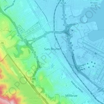
Nombre: Mapa topográfico San Bruno, altitud, relieve.
Altitud media: 53 m
Altitud mínima: -6 m
Altitud máxima: 367 m
According to the United States Census Bureau, the city has a total area of 5.5 square miles (14 km2), all of it land. The city spreads from the mostly flat lowlands near San Francisco Bay into the foothills of the Santa Cruz Mountains, which rise to more than 600 feet (180 m) above sea level in Crestmoor and more than 700 feet (210 m) above sea level in Portola Highlands. San Bruno City Hall sits at an official elevation of 41 feet (12.5 m) above sea level.
Otros mapas topográficos
Haga clic en un mapa para ver su topografía, su altitud y su relieve.
Redwood Junction
United States > California > San Mateo County > Redwood City
Redwood Junction, Redwood City, San Mateo County, California, 94063, United States
Altitud media: 9 m
Menlo Park
United States > California > San Mateo County
Menlo Park, San Mateo County, California, 94025, United States
Altitud media: 14 m
El Granada
United States > California > San Mateo County > Half Moon Bay
El Granada, Half Moon Bay, San Mateo County, CAL Fire Northern Region, California, 94018, United States
Altitud media: 122 m
San Mateo
United States > California > San Mateo County
San Mateo, San Mateo County, CAL Fire Northern Region, California, United States
Altitud media: 48 m
San Carlos
United States > California > San Mateo County > San Carlos > San Carlos
San Carlos, San Mateo County, California, 94070, United States
Altitud media: 47 m
San Carlos
United States > California > San Mateo County
San Carlos, San Mateo County, CAL Fire Northern Region, California, 94070, United States
Altitud media: 47 m