
Mapa topográfico Dourgouti Region
Mapa interactivo
Haga clic en el mapa para ver la altitud.
Acerca de este mapa
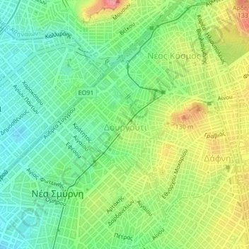
Nombre: Mapa topográfico Dourgouti Region, altitud, relieve.
Altitud media: 73 m
Altitud mínima: 26 m
Altitud máxima: 148 m
Otros mapas topográficos
Haga clic en un mapa para ver su topografía, su altitud y su relieve.
Lycabettus
Greece > Attica > Regional Unit of Central Athens > Athens
Lycabettus, Δώρας Δ' Ίστρια, Kolonaki, Συνοικία Κολωνακίου, 1st District of Athens, Athens, Municipality of Athens, Regional Unit of Central Athens, Attica, 106 76, Greece
Altitud media: 125 m
Philopappos Hill
Greece > Attica > Regional Unit of Central Athens > Athens
Philopappos Hill, Athens, Municipality of Athens, Regional Unit of Central Athens, Attica, 117 41, Greece
Altitud media: 73 m
Άλσος Βεΐκου
Greece > Attica > Regional Unit of Central Athens > Athens
Άλσος Βεΐκου, Galatsi, Athens, Municipality of Galatsi, Regional Unit of Central Athens, Attica, Greece
Altitud media: 171 m
Ιλισσός
Greece > Attica > Regional Unit of Central Athens > Athens
Ιλισσός, 7th District of Athens, Athens, Municipality of Athens, Regional Unit of Central Athens, Attica, 11527, Greece
Altitud media: 140 m