
Mapa topográfico Centerville
Mapa interactivo
Haga clic en el mapa para ver la altitud.
Acerca de este mapa
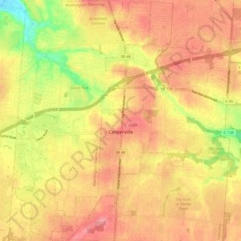
Nombre: Mapa topográfico Centerville, altitud, relieve.
Lugar: Centerville, Montgomery County, Ohio, United States (39.59062 -84.20869 39.67385 -84.09909)
Altitud media: 287 m
Altitud mínima: 226 m
Altitud máxima: 323 m
Otros mapas topográficos
Haga clic en un mapa para ver su topografía, su altitud y su relieve.
Patterson
United States > Ohio > Montgomery County > Dayton
Patterson, Dayton, Montgomery County, Ohio, 45408, United States
Altitud media: 233 m
Oakland
United States > Ohio > Montgomery County > Dayton
Oakland, Dayton, Montgomery County, Ohio, 45403, United States
Altitud media: 269 m
Washington Township
United States > Ohio > Montgomery County
Washington Township, Montgomery County, Ohio, United States
Altitud media: 285 m
North Riverdale
United States > Ohio > Montgomery County > Dayton
North Riverdale, Dayton, Montgomery County, Ohio, 45405, United States
Altitud media: 254 m
Shakertown
United States > Ohio > Montgomery County > Kettering
Shakertown, Kettering, Montgomery County, Ohio, 45420, United States
Altitud media: 282 m
Miami Township
United States > Ohio > Montgomery County
Miami Township, Montgomery County, Ohio, United States
Altitud media: 272 m
Hearthstone
United States > Ohio > Montgomery County > Dayton
Hearthstone, Dayton, Montgomery County, Ohio, 45420, United States
Altitud media: 273 m
Dayton
United States > Ohio > Montgomery County > Dayton
Dayton, Montgomery County, Ohio, 45423, United States
Altitud media: 270 m
Dayton
United States > Ohio > Montgomery County
Dayton, Montgomery County, Ohio, United States
Altitud media: 270 m
Kettering
United States > Ohio > Montgomery County
Kettering, Montgomery County, Ohio, United States
Altitud media: 275 m