
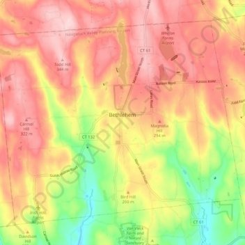
Mapa topográfico Bethlehem
Mapa interactivo
Haga clic en el mapa para ver la altitud.
Acerca de este mapa
Nombre: Mapa topográfico Bethlehem, altitud, relieve.
Altitud media: 255 m
Altitud mínima: 124 m
Altitud máxima: 346 m
Otros mapas topográficos
Haga clic en un mapa para ver su topografía, su altitud y su relieve.
East Cornwall
United States > Connecticut > Litchfield County > Cornwall
East Cornwall, Cornwall, Litchfield County, Connecticut, 06753, United States
Altitud media: 376 m
Washington Depot
United States > Connecticut > Litchfield County > Washington > Washington Depot
Washington Depot, Washington, Litchfield County, Connecticut, 06792, United States
Altitud media: 231 m
Kent
United States > Connecticut > Litchfield County
Kent, Litchfield County, Connecticut, United States
Altitud media: 255 m
Barkhamsted Reservoir
United States > Connecticut > Litchfield County > Barkhamsted
Barkhamsted Reservoir, Barkhamsted, Litchfield County, Connecticut, United States
Altitud media: 289 m
Woodbury
United States > Connecticut > Litchfield County > Woodbury
Woodbury, Litchfield County, Connecticut, 06798, United States
Altitud media: 181 m
Norfolk
United States > Connecticut > Litchfield County > Norfolk
Norfolk, Litchfield County, Connecticut, 06058, United States
Altitud media: 404 m
Candlewood Springs
United States > Connecticut > Litchfield County > New Milford > Candlewood Springs
Candlewood Springs, New Milford, Litchfield County, Connecticut, 06776-3413, United States
Altitud media: 146 m
New Preston
United States > Connecticut > Litchfield County > Washington > New Preston
New Preston, Washington, Litchfield County, Connecticut, 06777, United States
Altitud media: 250 m
Goshen
United States > Connecticut > Litchfield County > Goshen
Goshen, Litchfield County, Connecticut, 06756, United States
Altitud media: 374 m
Litchfield
United States > Connecticut > Litchfield County > Litchfield
Litchfield, Litchfield County, Connecticut, United States
Altitud media: 289 m
North Kent
United States > Connecticut > Litchfield County > Kent
North Kent, Kent, Litchfield County, Connecticut, 06757, United States
Altitud media: 259 m