
Mapa topográfico La Fouly
Mapa interactivo
Haga clic en el mapa para ver la altitud.
Acerca de este mapa
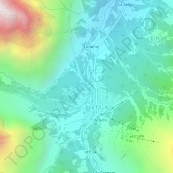
Nombre: Mapa topográfico La Fouly, altitud, relieve.
Lugar: La Fouly, Orsières, Entremont, Valais, 2303, Suisse (45.93622 7.09604 45.93633 7.09660)
Altitud media: 1.840 m
Altitud mínima: 1.485 m
Altitud máxima: 2.962 m
Otros mapas topográficos
Haga clic en un mapa para ver su topografía, su altitud y su relieve.
Aiguille d'Argentière
Aiguille d'Argentière, Orsières, Entremont, Valais, 2303, Suisse
Altitud media: 3.282 m
Glacier d'Orny
Glacier d'Orny, par la Moraine, La Deuve, Orsières, Entremont, Valais, 2303, Suisse
Altitud media: 2.921 m