
Gracias por apoyar a este sitio ❤️
Haz una donación
Haz una donación
Mapa topográfico Priddis
Haga clic en el mapa para ver la altitud.
Gracias por apoyar a este sitio ❤️
Haz una donación
Haz una donación
Priddis
Priddis is a hamlet in Alberta, Canada within Foothills County. It is located in the foothills of the Canadian Rockies at an elevation of 1,160 metres (3,810 ft). The hamlet is located southwest of the intersection of the Cowboy Trail (Highway 22) and Highway 22X, approximately 10 kilometres (6.2 mi) west of Calgary's city limits.
Gracias por apoyar a este sitio ❤️
Haz una donación
Haz una donación
Acerca de este mapa
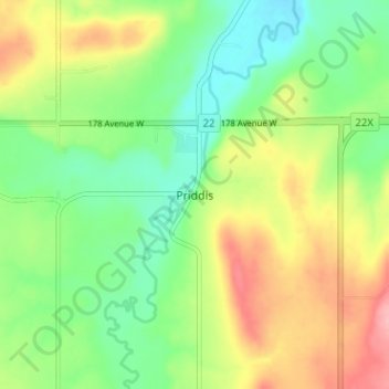
Nombre: Mapa topográfico Priddis, altitud, relieve.
Lugar: Priddis, Foothills County, Alberta, Canada (50.86479 -114.34574 50.90479 -114.30574)
Altitud media: 1.193 m
Altitud mínima: 1.146 m
Altitud máxima: 1.262 m
Gracias por apoyar a este sitio ❤️
Haz una donación
Haz una donación
Otros mapas topográficos
Haga clic en un mapa para ver su topografía, su altitud y su relieve.