
Mapa topográfico Rio Rancho
Mapa interactivo
Haga clic en el mapa para ver la altitud.
Acerca de este mapa
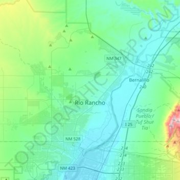
Nombre: Mapa topográfico Rio Rancho, altitud, relieve.
Lugar: Rio Rancho, Sandoval County, New Mexico, United States (35.17992 -106.86521 35.39438 -106.56700)
Altitud media: 1.672 m
Altitud mínima: 1.518 m
Altitud máxima: 2.487 m
Rio Rancho is in an arid climate due to its location in the rain shadow of the Sandia Mountains to the east and the Continental Divide to the west. Rio Rancho receives 8.90 inches of precipitation annually on average. The western portion of the city receives slightly more rain and snowfall due to its higher elevation than that of the more densely developed eastern portion of Rio Rancho.
Otros mapas topográficos
Haga clic en un mapa para ver su topografía, su altitud y su relieve.
Torreon
United States > New Mexico > Sandoval County
Torreon, Eastern Navajo Agency, Sandoval County, New Mexico, United States
Altitud media: 1.984 m
Cabezon
United States > New Mexico > Sandoval County
Cabezon, Sandoval County, New Mexico, United States
Altitud media: 1.888 m
Placitas Homesteads
United States > New Mexico > Sandoval County
Placitas Homesteads, Sandoval County, New Mexico, 87043, United States
Altitud media: 1.694 m