
Mapa topográfico Mitterfels
Haga clic en el mapa para ver la altitud.
Acerca de este mapa
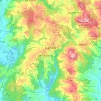
Nombre: Mapa topográfico Mitterfels, altitud, relieve.
Altitud media: 398 m
Altitud mínima: 325 m
Altitud máxima: 489 m
Otros mapas topográficos
Haga clic en un mapa para ver su topografía, su altitud y su relieve.
Niederlindhart
Deutschland > Bayern > Landkreis Straubing-Bogen > Mallersdorf-Pfaffenberg > Westen
Altitud media: 407 m
St. Leonhardsquelle
Deutschland > Bayern > Landkreis Straubing-Bogen > Mitterberg
Altitud media: 808 m
Westen
Deutschland > Bayern > Landkreis Straubing-Bogen > Mallersdorf-Pfaffenberg
Altitud media: 410 m
Sallach
Deutschland > Bayern > Landkreis Straubing-Bogen > Geiselhöring > Sallach
Altitud media: 372 m
Talmühle
Deutschland > Bayern > Landkreis Straubing-Bogen > Scheibelsgrub > Talmühle
Altitud media: 408 m