
Mapa topográfico Schuylkill Haven
Mapa interactivo
Haga clic en el mapa para ver la altitud.
Acerca de este mapa
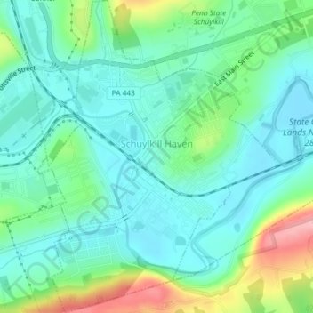
Nombre: Mapa topográfico Schuylkill Haven, altitud, relieve.
Altitud media: 184 m
Altitud mínima: 147 m
Altitud máxima: 287 m
Schuylkill Haven was developed around the Schuylkill River, which flows through the town entering northwest of Island Park near Fritz Reed Avenue, and exits at the southeastern border. The river's elevation in the borough is approximately 490 feet (150 m) above sea level. Farther from the river, the borough extends up numerous hills, reaching its highest elevation at approximately 700 feet (210 m) above sea level near the top of Avenue C.
Otros mapas topográficos
Haga clic en un mapa para ver su topografía, su altitud y su relieve.
Tamaqua
United States > Pennsylvania > Schuylkill County
Tamaqua, Schuylkill County, Pennsylvania, 18252, United States
Altitud media: 352 m
Frackville
United States > Pennsylvania > Schuylkill County
Frackville, Schuylkill County, Pennsylvania, 17931, United States
Altitud media: 446 m
Pottsville
United States > Pennsylvania > Schuylkill County
Pottsville, Schuylkill County, Pennsylvania, 17901, United States
Altitud media: 262 m